
Resource Cards
![]()
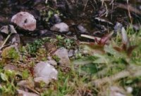
"Snively Creek is an oasis in the shrub-steppe ecoregion.
Photo: Andrea Currie
![]()
What is a riparian zone?
In the Columbia Basin you can easily recognize riparian zones as ribbons of green in an otherwise golden landscape. These sparse pockets of often tall trees and medium and small shrubs and grasses provide a sharp contrast to surrounding arid lands. Riparian comes from the Latin word ripa, which means bank. The dictionary defines riparian as "something that lives on the bank of a river or other body of water," a simple definition of a complex place! Generally, riparian areas are found around rivers and streams such as the Yakima, Columbia, or Snake, Rattlesnake Springs and Snively Creek. But, you'll also find riparian vegetation around irrigation ponds, gravel pits, and ditches. Riparian zones link water and dry land. Because of the presence of water in these areas, many different types of plants and animals can grow there than in surrounding shrub-steppe habitat. Riparian areas provide many benefits, including wildlife habitat, natural flood control, shoreline erosion control, pollution reduction, and recreation.
What plants are common to riparian areas in the Columbia Basin?
Along riparian areas of the Hanford Reach you're likely to see exotic woody species such as Siberian elm and Russian olive trees as well as willows, reed canary grass, cattail, and horsetail. Riparian shrubs and trees help keep stream temperatures cool in the summer, and their branches and leaves provide food for stream dwellers. At Rattlesnake Springs, peachleaf willow trees dominate riparian vegetation. Black cottonwood, shrub willow, and mock orange are common at Snively Creek. Other native shrubby species that grow near these streams include chokecherry, serviceberry, golden currant, wild rose, red-osier dogwood, and blue elderberry. Watercress grows abundantly in the spring streams. In some riparian areas of the Columbia Basin, short, shrubby willows grow in stands so thick it is nearly impossible to walk through them. Native Americans in Oregon who used these kinds of areas gave them the name Ochoco, which means willow-covered stream.
What wildlife species are common to riparian areas in the Columbia Basin?
In dry lands, springs and streams are magnets for wildlife. Only 1 percent of the land in arid regions of the Pacific Northwest is riparian, yet over 90 percent of the animals that live in these areas use them for food, nesting, resting, shelter, and/or water. For example, streamside habitats provide food for waterfowl such as Canada geese and shore birds, including killdeer and spotted sandpiper. The riparian zone also provides food and cover for flocks of dark-eyed junco, white-crown sparrow, American robin, and other species. Great blue heron, black-billed magpie, and Bullock's oriole all nest in riparian habitat as do the Swainson's hawk, red-tailed hawk, and great horned owl. In winter, bald eagles perch and roost in trees along the Hanford Reach. One bird, the bank swallow, is found in riparian areas so often it was given the scientific name Riparia riparia.
Beaver and muskrat rely on riparian habitat for foraging and denning materials. Rattlesnake Springs and Snively Creek provide drinking water and important cover and forage for mule deer and Rocky Mountain elk. Many reptiles and amphibians could not survive our harsh arid environment without a dependable source of water in which to lay eggs or provide food. These include the common garter snake and Great Basin spadefoot toad. Abundant but often unnoticed insects such as mayflies, stoneflies, caddisflies, and beetles are overshadowed by the more noticeable mosquitoes, blackflies, and gnats. Riparian insects provide important links in the food web of arid lands and are eaten by many other animals such as shrews, fish, and birds. Spiders are also part of the natural riparian environment.
How have local riparian areas changed?
Over the last 100 years, most riparian areas in the Columbia Basin have been altered as a result of human development. Early settlers used riparian areas to graze livestock. Later, dams built to control flooding and provide water for irrigation either flooded or dried up many riparian areas. In recent years, though, the values associated with riparian zones have prompted local, regional, and national action to preserve and maintain these areas for wildlife and fish.
![]() "Science is constructed of facts as a house is of stones. But a collection of facts is no more a science than a heap of stones is a house." -Henri Poincare
"Science is constructed of facts as a house is of stones. But a collection of facts is no more a science than a heap of stones is a house." -Henri Poincare
Keep in mind this fact sheet is intended to be used only as background information to support your effort to encourage inquiry-based science, which parallels the way scientists uncover knowledge and solve problems.
![]()
1. Explore current and historic riparian areas.
Explore current and historic riparian areas around the Tri-Cities (Badger Spring, Barrel Springs, Bateman Island, Cliff Spring, Cold Creek, Hanford Reach, Horn Rapids, Juniper Springs, Snipes Creek. See Benton County Place Names, 1996. Jean Carol Davis and Vickie Silliman Bergum, East Benton County Historical Society, for a description of these sites and their locations). Do they still exist? If not, why not? If so, walk through the area and closely observe the plants as you approach the edge of the water. Do the plant species change? Where in the riparian area do the tallest plants grow? The shortest? As you look at the different plants, how wet is the soil around each species? Use a journal, sketchpad, or camera to help you be a careful observer. Can you name riparian zones in your area that have been created near your home or school as a result of irrigation or other human activities?
2. Draw a food web that shows who eats what in a particular riparian zone.
Draw a food web that shows who eats what in a particular riparian zone. Show feeding relationships with arrows that indicate the diet of various members of the web. For children 5 years and above, a game called "Webbing" helps students better understand the interrelationships among air, rocks, plants, and animals in the web of life. (See Sharing Nature with Children, 1979. Joseph Bharat Cornell, Ananda Publications, Nevada City, California).
3. Learn more about wetlands.
Call the U.S Environmental Protection Agency's Wetlands Information Hotline (1-800-832-7828) for more information about wetlands. The Hotline operates Monday through Friday from 9:00 a.m. to 5:30 p.m. Eastern Standard Time.
![]()
- Celebrating Wildflowers: An Educator's Guide to the Appreciation and Conservation of Native Plants of Washington, Wendy Scherrer and Traci Johannessen, 1996, North Cascades Institute, Sedro Woolley, Washington.
- Full Option Science System (FOSS), Lawrence Hall of Science, University of California, Berkeley, California. Water (Grades 3-4, Landforms [Grades 5-6]).
- Great Explorations in Math and Science (GEMS), University of California, Berkeley, California, River Cutters (Grades 6-9), School Yard Ecology (Grades 3-6).
- National Science Resource Center: Science and Technology for Children (STC), National Academy of Sciences, 1996, Washington, D.C. Land and Water (Grade 4), Ecosystems (Grade 5).
- Outdoor Biology Instructional Strategies (OBIS), Lawrence Hall of Science, University of California, Berkeley, California.
- Riparian Landscapes, 1996. George P. Malanson, Cambridge University Press, New York.
- Sharing Nature with Children, 1979. Joseph Bharat Cornell, Ananda Publications, Nevada City, California.
- Wetland Plants of Oregon and Washington, 1995. Jennifer Guard, Lone Pine Publishing, Redmond, Washington.
- Wetlands, 1985. William A. Niering, National Audubon Society Nature Guides, Alfred A. Knopf, New York.
- Wildflowers of Marsh and Waterway, 1974. Lewis J. Clark, Gray's Publishing Limited, Sidney, British Columbia.
![]()
- Birds as Indicators of Riparian Vegetation Condition in the Western U.S. - http://www.npwrc.usgs.gov/resource/
- BLM Teaching Resource - http://www.blm.gov/education/Learning
Landscapes/teachers/ecosystems_riparian.html - North American Native Fishes Association—;Riparian Zone - http://www.nanfa.org/education/carillio/insects.htm
- Riparian Ecosystem Creation and Restoration: A Literature Summary - http://www.npwrc.usgs.gov/resource/
- USDA—ARS Hydrology and Remote Sensing Laboratory - http://hydrolab.arsusda.gov/ope3/slideshows/angier/jashow.htm
![]()
Initial development and printing was funded by the Partnership for Arid Land Stewardship. Written by: Jon Merz, The Nature Conservancy of Washington, and Janelle Downs. Series Editor: Georganne O'Connor; Design: WinSome Design; Printing: Eagle Printing and Graphic Design. First Printing: April 1999.
![]()