
Resource Cards
![]()
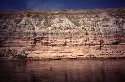
The Hanford Reach flows 51 miles from Priest Rapids Dam to Richland.
![]()
What is the Hanford Reach?
The Hanford Reach is the last free-flowing stretch of the Columbia River in the United States. The Reach includes the river itself and lands on both sides of the river. It flows 51 miles from approximately Priest Rapids Dam to Richland, Washington, and provides the last significant fall chinook spawning habitat in the main stem river. The area also supports numerous species of birds, mammals, reptiles, and amphibians, including some recognized as species of concern by state and federal governments. The Reach shelters American Indian cultural resources and important archaeological sites.
What kinds of habitat are found in the Hanford Reach?
Three major kinds of habitats - aquatic, riparian, and upland - can be found in the Hanford Reach system. Aquatic habitats, covered with water most of the year, include the main channel of the Columbia River, near-shore, and backwater sloughs. Riparian habitat - a narrow strip of land near the water - includes cobble shorelines and islands. Riparian areas provide important habitat for fish, birds, and invertebrates. They also provide vegetation for food and cover for other species. Upland habitats adjacent to the Hanford Reach include island, dune, and bluff habitats, including the White Bluffs, a unique geologic feature that contains ancient fossils. The White Bluffs fossil record extends back more than two million years.
Who inhabits the Hanford Reach?
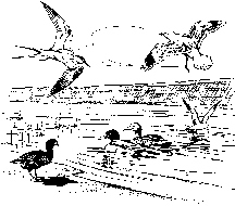
Many waterfowl inhabit the Reach, including mallards, teal, gadwall, white pelicans (a state-endangered species), and the American merganser. The familiar Canada geese also can be seen and heard along this reach of river. Colonial nesting birds include the Forster's tern, California gull, ring-billed gull, and great blue heron. Bald eagles (a federally threatened species) historically winter along the Hanford Reach. Scientists have counted as many as 55 (in 1987) eagles near the old Hanford town site. They feed on fish, spawned-out salmon carcasses, and small waterfowl. Public lands bordering the Reach are home to 48 rare, threatened, or endangered species.
If you take a river boat trip up the Reach or walk along public lands bordering the river, such as the Wahluke Wildlife area, you might see a variety of wildlife. Mule deer, coyotes, and beaver are familiar sights. But elk, muskrat, raccoon, skunk, weasels, and bobcats also are known to inhabit the area. Black-tailed jackrabbits and cottontails live in sagebrush and riparian vegetation along with such creatures as painted turtles, western terrestrial garter snakes, western rattlesnakes, gopher snakes, short-horned lizards, and side-blotched lizards. Recently, scientists discovered many new species of insects along the Reach, including six species of bees, six of flies, four of leafhoppers, one wasp, and one beetle.
As for fish, many species pass through the Reach every day, including fall chinook, coho, and sockeye salmon; steelhead; and white sturgeon. Resident fish include smallmouth bass, common carp, mountain whitefish, mountain sucker, sandroller, paiyte sculpin, and reticulate sculpin.
![]() "Science is constructed of facts as a house is of stones. But a collection of facts is no more a science than a heap of stones is a house." Henri Poincare.
"Science is constructed of facts as a house is of stones. But a collection of facts is no more a science than a heap of stones is a house." Henri Poincare.
Keep in mind this fact sheet is intended to be used only as background information to support your effort to encourage inquiry-based science, which parallels the way scientists uncover knowledge and solve problems.
![]()
Learn about the Hanford Reach.
Take a boat tour up the Reach with friends or with a local tour boat company, or walk along the river north of Ringold at the Wahluke Wildlife Area or Saddle Mountain National Wildlife Refuge. What is the habitat like along the river? What kind of animals do you see? What kinds of plants? How does the habitat change as you move away from the river? Do you see different plants and animals? How do you think animals and plants are adapted to survive in these habitats?
Visit the Reach during different seasons - do you see different animals and plants? Keep a journal of the plants and animals you observe on the Reach - include information on where you observed them, what the weather was like, the time of day, what time of year. Include a photograph or draw a picture of the plants and animals.
Look closely at the geology of the Reach as you travel along the river or walk along its banks. How does the geology change as you travel along the River? Research the geologic history of the Reach. Compare the geology of the Reach to the Wallula Gap or the Columbia River Gorge.
Monitor the velocity of a river.
For this activity, you will need an orange, a tape measure, either a stopwatch or a watch with a second hand, and friends to assist you. Pick a spot along the shore of a river that you can easily get to during the year. Using your tape measure, measure out 10 meters along the bank of the river. Have one person place the orange in the water at the upstream end of the tape. Start the timer as soon as the orange is released. When the orange gets to the end of the tape, stop timing. To find out the velocity of the river in meters/second divide the number of meters by the number of seconds. Repeat the experiment at least 3 times and average the results. In a notebook record the date, time of day, weather, and the average velocity of the river in meters/second.
Questions a scientist might ask: Does the velocity of the river vary month to month? Why does the velocity change? What is happening upstream that can have an effect on the velocity of the river? What is the effect of the velocity of the river on the animals and plants that live in the river?
![]()
- Aquatic and Riparian Resource Study of the Hanford Reach, Columbia River, Washington, D. Fickeisen, Dennis Dauble, and Duane Neitzel, 1980. Pacific Northwest National Laboratory, Richland, Washington. (Available at the Consolidated Information Center Libraries, WSU-Tri-Cities).
- I Am of This Land - Wildlife of the Hanford Site, Dan Landeen and Jeremy Crow, 1997. Western Printing, Clarkston, Washington.
- Shrub-Steppe Seasons: A Natural History of the Mid-Columbia Basin, Lee E. Rogers, 1995. Pacific Northwest National Laboratory, Richland, Washington (Available at the
Consolidated Information Center Libraries, WSU-Tri-Cities).
- Spawning and Abundance of Fall Chinook Salmon in the Hanford Reach of the Columbia River, 1948-1988, Dennis Dauble and Don Watson, 1990. Pacific Northwest National Laboratory (Available at the Consolidated Information Center Libraries, WSU-Tri-Cities).
- The Hanford Reach: What Do We Stand to Lose?, David R. Geist, 1995. Illahee 11 (3&4):130-141.
- Great Explorations in Math and Science (GEMS), Lawrence Hall of Science, River Cutters (6-9), Mapping Fish Habitats (6-10).
![]()
- Great Plains - Palouse Dry Steppe Province - http://www.fs.fed.us/colormap/ecoreg1_provinces.conf?237,131.html
- U.S. Fish and Wildlife Hanford Reach National Monument - http://hanfordreach.fws.gov/
- What is the Hanford Reach? - http://www.hanfordreach.org/
![]()
Initial development and printing of this fact sheet was funded by an Eisenhower Grant to the Partnership for Arid Lands Stewardship. Series Editor: Georganne O'Connor; Design: WinSome Design; Printing: Eagle Printing and Graphic Design; First Printing: December 1997; Web Development: WinSome Design
![]()